SPATIAL DATABASES

|
|
SPATIAL DATABASES |
|
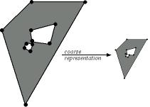
The problem of multiple representations consists of data changing their geometric and topological structure due to changes in scale. Conceptually, multiple representations may be considered as different data sets that cover the same area with different levels of detail. Within the context of assessing consistency at multiple representations, topological relations are considered to be first-class information, which must prevail in case of conflicts. This means that, at different scales, there is no inconsistency in having different geometric representations of a same object if some topological constraints are satisfied.
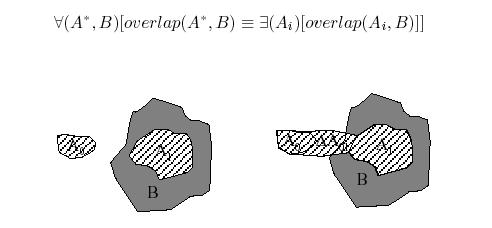
The basic assumption when defining consistency rules for topological relations at multiple representation levels is that the goal of a coarse representation is to reduce the complexity of objects. For objects with holes, this means that the number of holes should be reduced in a coarse representation. Likewise, the number of boundary-boundary intersections between holes and between a generalized region and a hole should get smaller. If the topological relation between holes change, it changes from disjoint to meet. Thus, the dimension may increase from one to another representation. For example, if two holes are moved closer to each other, a component intersection that meets in a node may change to a meet in an edge. Like these basic rules, many other rules exist for objects with holes and for relations between objects with holes in different representations.
In summary, multiple representations in spatial databases may not imply inconsistent information, but rather, merely different levels of detail or scale. In such cases, topological consistency at the level of objects and objects' relations must be analyzed. Analyses of consistency at multiple representational levels are not included in current commercial DBMS, they are running as ad-hoc applications. From the perspective of consistency in spatial databases, models of consistency at multiple representational levels lack the specification in a formal language for their treatments as integrity constraints.
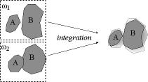
Consistency in spatial information integration considers cases where spatial data sets to be integrated contain the same features or objects, which can be extracted from several sources at different times. The treatment of consistency when integrating data sets with different features (e.g., combining cadastral with water resource data) depends on the semantics of the features involved.
The integration of the same features from different sources may vary in reliability, accuracy and scale of representation. Thus, integrating spatial information may create conflicts due to the different representations for the same features concerning, for example, shape, dimension, and positional accuracy.
In the context of data integration, different types of consistency at the same representational level are distinguished:
Total consistency occurs when two configurations or data sets (i.e., when elements or objects that compose configurations) are identical.
Partial consistency occurs when partial configurations are identical (i.e., when subsets of elements that compose configurations are identical).
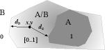
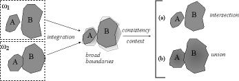
The common approach to integrating different representations has assumed that when no further information exists about the origin of data, both representations are considered to equally contribute to the integration of information. In cases of multiple representational levels, a preliminary step is to check whether or not different representational levels are consistent. When representational levels are consistent, a more detailed level can be mapped onto and integrated into a less detailed level; that is, into a representation generated by a generalization process. If, at a common representational level, two different representations exist, partial consistency may still be possible (i.e., parts of the different representations of an object or configuration are identical). The idea is to merge both representations in such a way that the resulting representation is modeled as a vague or unclear one. In modeling these unclear boundaries, three alternatives are found:
Fuzzy models, which are based on fuzzy set theory and have been applied to spatial uncertainty. Fuzzy set theory is an extension of classical boolean set theory that deals with different degrees of possibility that an individual is a member of a set or that a given statement is true . Examples of fuzzy spatial objects are mountains, cities, and oceans.
Probabilistic models, which are based on probability theory to model positional and measurement uncertainty. Probabilistic approaches model uncertainty by determining a degree of membership of an entity in a set in terms of statistically defined functions. An example of an unclear boundary that can be modeled by a probabilistic model is the water level of a lake that is not certainly known.
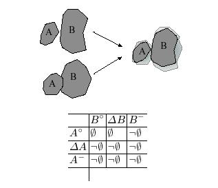
Exact models, which map data models for spatial objects with sharp boundaries onto spatial objects with broad boundaries. Combining broad boundaries, it is possible to derive possible topological relations.
| |
|